Lake Lucerne (Vierwaldstättersee): The Convoluted Fjord of Central Switzerland
Lake Lucerne defies the simple oval or elongated trough shape typical of many subalpine basins. Instead, it forms four distinct basins and four reach arms connected through narrow straits formed by complex glacial erosion along pre-existing geological fault lines. Its surface lies at 434 meters elevation, rimmed by precipitous massifs including Mount Pilatus (2,128m), the Rigi (1,798m), and the Stanserhorn (1,898m).
Because of this intricate geography, navigating Lake Lucerne feels like traversing multiple enclosed mountain fjords. The southernmost arm, the Urnersee, features sheer rock faces plunging directly into dark waters where historical Swiss confederal traditions originated at the Rütli meadow.
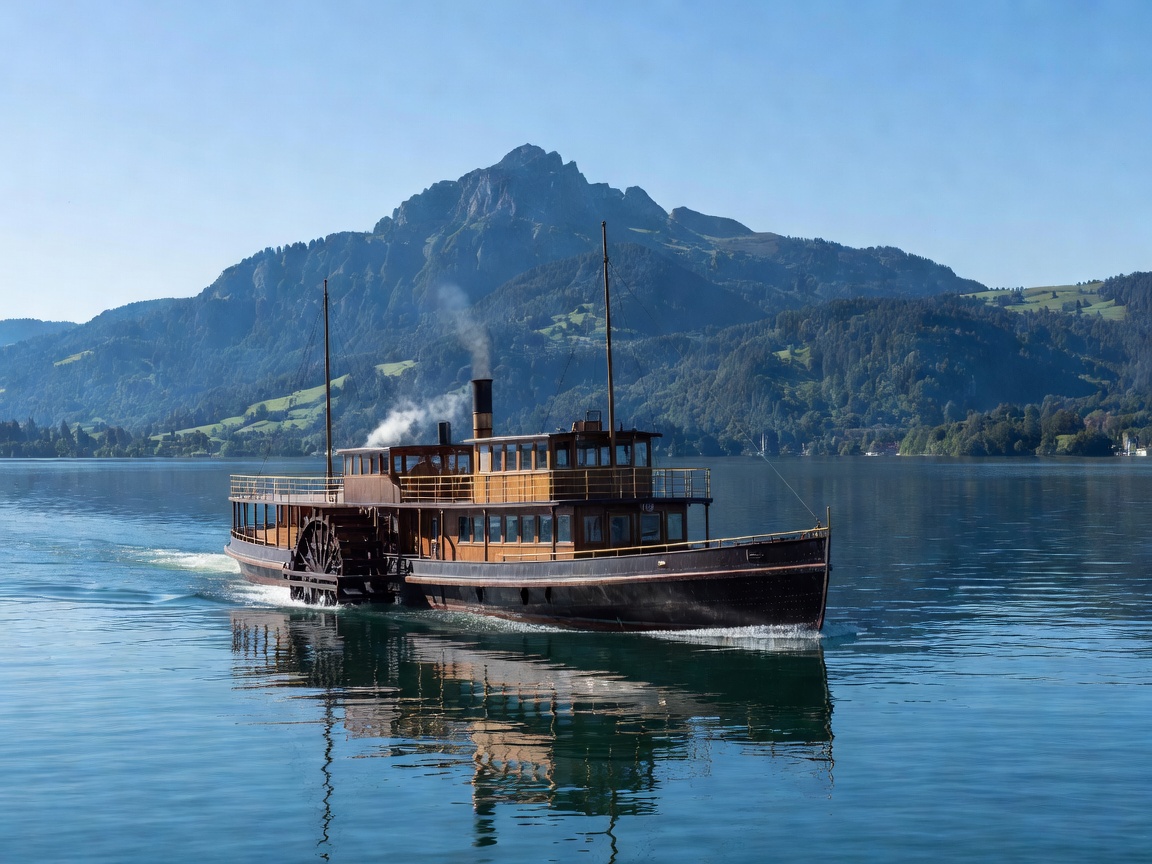
The Steam Paddle Fleet & Cogwheel Integration
Lake Lucerne boasts the world's largest fleet of active Belle Époque paddle steamers operated by the Schifffahrtsgesellschaft des Vierwaldstättersees (SGV). These five coal- and oil-fired paddle vessels, built between 1901 and 1928, operate in daily scheduled passenger service alongside modern motor vessels.
The lake journey connects seamlessly with historic mountain transport. At Vitznau, passenger ferries dock directly beside the lower terminus of the Vitznau-Rigi Bahn, established in 1871 as Europe's first mountain cogwheel railway. On the opposite shore, at Alpnachstad, the Pilatusbahn climbs at a maximum gradient of 48%—the steepest rack railway in the world.
Navigational Heritage
Before rail tunnels were bored through the Gotthard massif, Lake Lucerne served as the essential maritime bridge on the north-south trade corridor connecting Basel and Zurich to northern Italy over the Gotthard Pass.
Lake Geneva (Lac Léman): The Crescent Inland Sea
Forming a massive 73-kilometer crescent shared between Switzerland and France, Lake Geneva is the largest body of water in the Alps by both volume (89 km³) and surface area (580 km²). Fed by the silt-laden waters of the upper Rhône river entering at Le Bouveret, the lake acts as a vast settling basin before discharging clean, azure water through the center of Geneva.
The northern Swiss shoreline, stretching through the canton of Vaud from Lausanne to Montreux, faces southward toward the French Chablais Alps. This orientation maximizes sun exposure and reflects light off the water surface onto the steep hillside vineyards of the Lavaux, an engineered landscape of stone terraces dating back to 11th-century Benedictine monasteries.
Active Exploration: The Lavaux Path & Dents du Midi Vistas
The 32-kilometer marked hiking trail through the Lavaux vineyard terraces provides an unbroken vantage across the broad water toward the glaciated peaks of the Dents du Midi and Grand Combin. The trail connects small wine villages such as Saint-Saphorin, Rivaz, and Epesses, where regional trains running parallel to the water allow travelers to shorten or extend day hikes at will.
Near Montreux, the fortified island stronghold of Château de Chillon sits directly on an elliptical limestone outcrop in the lake, demonstrating medieval defensive mastery over the lake route and the ancient road toward the Great Saint Bernard Pass.
Technical Comparison: Lucerne vs. Geneva
| Parameter | Lake Lucerne (Central CH) | Lake Geneva / Lac Léman (Romandy CH/FR) |
|---|---|---|
| Surface Elevation | 434 m | 372 m |
| Maximum Depth | 214 m (Gersau Basin) | 310 m (Grand Lac) |
| Water Volume | 11.8 km³ | 89 km³ |
| Shoreline Perimeter | 143.7 km (Irregular fjord branches) | 200.2 km (Smooth crescent) |
| Primary Historic Fleet | 5 Belle Époque Steamers (SGV) | 8 Belle Époque Steamers (CGN) |
| Transit Pass Compatibility | Swiss Travel Pass (Full ferry coverage) | Swiss Travel Pass • Léman Pass |
Planning Notes, Weather & Recommendations
Advantages
- Clockwork intermodal connections: Steamer docks are positioned adjacent to SBB rail stations in Lucerne, Lausanne, Montreux, and Geneva.
- Dramatic elevation relief: Both lakes feature mountain summits rising 1,500 to 2,000 meters directly above the shoreline within horizontal spans of just 2 to 4 kilometers.
- Year-round operation: Unlike smaller high-altitude tarns that freeze completely, major passenger vessels run scheduled services all twelve months.
Practical Realities
- Sudden mountain squalls: Lake Lucerne's Urnersee basin is prone to violent Föhn winds blowing down from the Alps, creating swift changes in water conditions for small craft.
- Seasonal water temperature: Due to snowmelt and great water depths, swimming is generally cold until mid-July, peaking at around 19°C to 22°C in sheltered bays.